Pie Charts - Sea Level Rise Increases Flood Frequencies
Sea level rise can turn minor tidal flooding into a daily event.
Based on analyses of three years (Oct 2007 to Sep 2010) of observed
tides at Mobile, AL (L. Brown, NOAA CO-OPs, written commun. 2010).
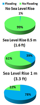
With no sea level rise (current conditions), only about 1% of time flooding occurs at Mobile, AL. About 1% or less of time, flooding occurs at Waveland, MS, and Pensacola, Panama City, and Apalachicola, FL.
With 0.5 m (1.6 ft) sea level rise, about 39% of time flooding could occur at Mobile, AL. About 22% to 50% of time flooding could occur at Waveland, MS, and Pensacola, Panama City, and Apalachicola, FL.
With 1 m (3.3 ft) sea level rise, about 78% of time flooding could occur at Mobile, AL. About 90% to 98% of time flooding could occur at Waveland, MS, and Pensacola, Panama City, and Apalachicola, FL.
Based on additional NOAA CO-OPs analyses of three years of tide data at Waveland, MS, and Pensacola, Panama City, and Apalachicola, FL (L. Brown, NOAA CO-OPs, written commun. 2010, 2011)
Return to the map of predicted Sea Level Rise Impacts
Map - Current Storm Tide Flood Levels
This map shows minor flooding from the Gulf that now happens only during storm events.
Minor flooding (minimal or no property damage, but possibly some public inconvenience)
is at 3 ft MLLW or elev. 2.5 ft NAVD88 threshold selected by the National Weather Service
for issuing coastal flood advisories at Mobile, AL.